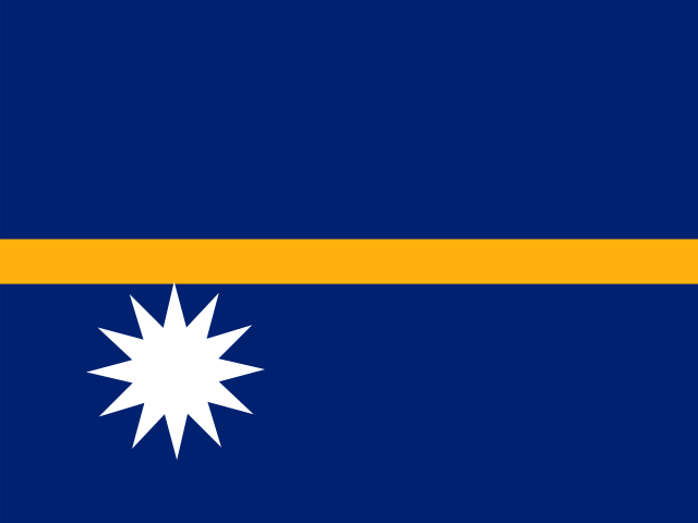
The Flag of Nauru
Oceania · Adopted 31 January 1968 (independence day)
Nauru's flag was adopted on 31 January 1968, the day the tiny island — barely 21 square kilometers, one of the smallest independent states in the world — became a republic, ending a long sequence of external administrations that had run from German colonization in 1888 through Australian, British, and New Zealand joint trusteeship after the First World War, Japanese occupation during the Second World War, and a postwar UN trusteeship administered again by Australia.
The flag's design is unusually literal for a national symbol: a deep blue field represents the Pacific Ocean, a narrow horizontal gold stripe running across the middle represents the equator, and a white twelve-pointed star sits just below that stripe, positioned precisely to mark Nauru's own real geographic location — the island sits about one degree south of the equator, and the star's placement below rather than on the gold line is a direct, to-scale representation of that fact rather than a symbolic approximation.
The twelve points of the star represent the twelve original tribes or clans that Nauruan society was traditionally organized into before and during the colonial period, a detail that ties the flag to Nauru's indigenous social structure rather than to any imported religious or political symbolism, distinguishing it from many other Pacific flags built around Christian crosses or colonial coats of arms.
Nauru's modern history is inseparable from phosphate. The island's interior was, for most of the 20th century, an extraordinarily rich phosphate deposit formed from millennia of seabird guano, and its extraction — first under German and then joint British-Australian-New Zealand control, and after independence by the Nauruan government itself — made Nauru briefly one of the wealthiest countries per capita in the world during the 1970s. None of that history appears directly on the flag, which was designed the year before independence through a public competition, but it defines the economic and environmental story of the nation the flag represents: phosphate mining left roughly 80% of Nauru's interior as a barren, uninhabitable moonscape, and the country has struggled economically since reserves were largely exhausted by the 1990s.
Nauru is unusual among small nations for not maintaining a standing military, and it has instead relied on a series of bilateral security and financial arrangements with Australia — including, controversially since 2001, hosting an Australian-funded offshore immigration detention center — arrangements that have shaped Nauru's international profile considerably more than its flag or phosphate history alone would suggest today.
During its 1970s phosphate boom, the Nauruan government invested export revenue into overseas real estate and business ventures, most famously Nauru House, a high-rise office tower in Melbourne purchased in 1977, along with hotels and other holdings across Australia and the Pacific — investments intended to fund the country after phosphate ran out, though mismanagement and speculative losses through the 1990s and early 2000s left far less of that wealth intact than the original investment strategy had anticipated.
Nauru joined the United Nations only in 1999, alongside Tonga, Kiribati, and Tuvalu, making it and Tuvalu the smallest sovereign states by population ever admitted to full UN membership at the time — a milestone that came three decades after Nauru's own 1968 independence, reflecting how long some of the smallest Pacific states waited before joining a body originally designed around much larger member states.
The Nauruan language itself is a linguistic isolate within the Micronesian language family, unrelated closely enough to any neighboring Pacific language to be easily grouped with them, and with a total speaker population in the low thousands it is classified by linguists as vulnerable — a fact that gives added weight to the flag's twelve-point star, since it ties national identity to the same twelve clan groupings that have historically carried and preserved Nauruan language and custom across generations.
The flag has not been redesigned since 1968, and its precise geographic symbolism — a star placed to mark an actual line of latitude — remains one of the more mathematically literal designs among the world's national flags, a detail vexillologists frequently cite when discussing flags that encode real geographic coordinates rather than purely abstract symbolism.
Nauru's official construction sheet sets the flag to a 9:17 ratio, noticeably more elongated than the 2:3 or 1:2 proportions used by most nations, and fixes the gold equatorial stripe at a specific fraction of the flag's total height along with the exact diameter and point-length of the white star beneath it, so the geographic proportion the design is meant to represent stays consistent on every flag manufactured. The design was chosen through a public competition run by Nauru's Legislative Council in the years before independence; available government and vexillological records do not consistently agree on which individual entrant is credited with the winning submission, an honest gap in the record for a flag whose symbolism is otherwise so precisely documented.
Alongside Independence Day, Nauru observes Angam Day each 26 October, a national holiday found nowhere else in the world: it commemorates the island's population recovering to, and then surpassing, 1,500 ethnic Nauruans after twice being pushed toward that threshold by disease and depopulation crises earlier in the 20th century, a demographic milestone treated as a matter of literal national survival rather than a routine anniversary. Government buildings fly the flag for both occasions, and the same twelve-point star that marks the island's traditional clans on the flag is the detail Nauruan civics education most often ties back to Angam Day's own theme of the community's continuity across generations.
Independence Day, 31 January, remains Nauru's principal national holiday and the flag's central annual occasion, marked on an island whose entire population can gather for national ceremonies in a way few other countries' can.
A 9:17 cut with one thin stripe
- Flag cut to 9:17 — The gold stripe is set at a stated fraction of a field specified at 9:17, so a stock cut both changes the outline and moves the stripe off the line it is meant to mark.
As an Amazon Associate we earn from qualifying purchases made through these links, at no extra cost to you.
Often confused with
- Marshall Islands — both are plain blue Pacific-ocean fields with a single geometric device in white or gold picking out a specific real-world feature of the country's geography, but Nauru's design is a horizontal equator line with a twelve-point star beneath it, while the Marshall Islands uses rising diagonal orange-and-white stripes with a 24-point star, a visually busier and differently structured design. Compare side by side →
Nauru at a glance
- Capital
- Yaren
- Population
- 12,500 (2024)
- Currency
- Australian Dollar (AUD)
- Language(s)
- Nauruan (national language) and English (used in government and commerce)
Population figure as of 2024, source: UN World Population Prospects (2024 revision). See methodology for how facts are sourced and kept current.